
Community
Santa Cruz County 2026 general election in charts: The latest results after Friday’s update
By Marcus Chen
Advertisement · Why this ad?
Katherine oversees editorial operations across all six brands. Before joining The Meridan Group, she spent 14 years at the Minneapolis Star Tribune, where she led the metro desk through its digital transformation. She holds a Master's in Journalism from Northwestern's Medill School.
More from Katherine →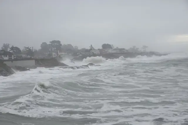
The familiar rhythm of waves crashing against the Santa Cruz coastline is about to shift, bringing with it a stark warning for residents. As families plan weekend activities, the prospect of torrential rain and towering surf—potentially reaching 30 feet—demands a change in plans and a heightened awareness of coastal hazards. A stormy weekend is ahead, with rain expected to arrive Thursday night and hazardous coastal conditions forecast through early Sunday, Nov. 15.
The National Weather Service (NWS) has issued a series of warnings designed to keep Santa Cruz County residents safe. A high surf warning will take effect at 6 p.m. Friday and remain active until Sunday at 4 a.m., following a beach hazards statement that began Wednesday morning and continues through 6 p.m. Friday. These advisories warn of an increased risk of “sneaker waves” and strong rip currents, with breaking waves initially reaching 15 to 20 feet. Once the high surf warning takes effect Friday evening, dangerously large breaking waves of 25 to 30 feet are forecast, with the most significant surf expected on Saturday. The potential for dangerous surf is amplified by coinciding high tides, creating a particularly perilous combination.
Tide predictions from the National Oceanic and Atmospheric Administration (NOAA) reveal a concerning alignment. Friday’s high tide is expected around 11:28 a.m., reaching approximately 5 feet, with the lowest tide at 7:24 p.m. (0.02 feet). Saturday’s high tide is forecast for 12:11 p.m., reaching an estimated 4.7 feet as the biggest surf is anticipated, falling to a low of 0.20 feet by 8:14 p.m. Sunday’s high tide is projected at 1:06 p.m., reaching about 4.4 feet, with a low of 0.37 feet at 9:04 p.m. The NWS strongly urges residents to avoid beaches and the ocean entirely while these advisories are in effect, emphasizing the potentially life-threatening nature of the conditions.
The dangers extend beyond swimmers; powerful waves can sweep people into the ocean from the shoreline, while strong currents can pull individuals towards sharp jetties and rocks, increasing the risk of drowning or serious injury. As ABC7 meteorologist Drew Tuma noted, “Most Bay Area cities are forecast to receive about a half-inch of rain, with higher amounts possible in the North Bay and Santa Cruz Mountains. Rainfall totals are expected to range from 0.50 to more than 1.5 inches, accompanied by wind gusts of 30 to 50 mph.” The NWS reminds everyone to “never turn your back on the ocean,” a simple but vital precaution. This warning is particularly crucial given the history of incidents in Santa Cruz County where individuals have been caught off guard by unexpected wave action, highlighting the importance of constant vigilance near the coast. The Santa Cruz Harbor Patrol and the County Sheriff's Office Marine Unit will be increasing patrols during this period to monitor conditions and provide assistance if needed.
The potential for dangerous surf extends beyond the immediate coastline. Experienced surfers are echoing the NWS’s warnings, emphasizing the unpredictable nature of the ocean. “The water's getting aggressive. It’s growing. The swell is increasing,” said Pacifica surfer Craig Garza, highlighting the rapid changes in conditions that can catch beachgoers off guard. Curtis Wedge, another surfer, cautioned, “Don't let your kids out anywhere near the water. These tides will suck them kids right out. It’s dangerous.” Large waves were already visible at Pacifica's Linda Mar Beach and San Francisco's Ocean Beach, with surf expected to increase throughout the week. The combination of high surf and high tides creates a particularly hazardous environment, especially for those unfamiliar with ocean conditions. The term “sneaker wave” refers to unexpectedly large waves that can appear without warning, often between sets of smaller waves. These waves are particularly dangerous because they can catch people off guard and sweep them into the ocean. Local authorities are urging residents to be aware of their surroundings and to avoid standing close to the water’s edge, especially during high tide and periods of increased surf.
While coastal forecasts emphasize the surf hazard, the Santa Cruz Mountains will also experience significant rainfall. Friday’s forecast calls for rain before 10 p.m., with amounts between a tenth and quarter of an inch possible. Saturday morning has a 20% chance of rain and is expected to be foggy before 11 a.m., with the remainder of the day relatively clear. For Sunday, rain is mainly predicted after 4 p.m. and is forecast to continue steadily into the night. Residents in the mountain communities should prepare for potential road closures and increased runoff, especially given the saturated ground conditions, and be aware that rainfall amounts may differ from those closer to the coast. The Santa Cruz Mountains are known for their steep slopes and narrow roads, making them particularly vulnerable to landslides and mudslides during periods of heavy rainfall. The County Office of Emergency Services is advising residents in the mountain areas to clear gutters and downspouts, secure loose objects in their yards, and be prepared to evacuate if necessary. Knowing evacuation routes and having a disaster preparedness kit readily available is crucial for mountain residents.
Given the potential for dangerous conditions, residents are strongly encouraged to stay informed and take precautions. Residents can CruzAware alert-notification system for the county’s CruzAware alert-notification system to receive real-time updates and warnings. This system provides crucial information during emergencies, allowing residents to make informed decisions about their safety and the safety of their families. The system utilizes SMS messaging, email, and phone calls to disseminate critical information quickly and effectively. For the latest weather updates and warnings, residents can visit the National Weather Service website. Tide predictions are available from Tides4Fishing. Local radio stations, such as KUSP 88.9 FM and KZZK 94.9 FM, will also be providing weather updates throughout the weekend.
The convergence of heavy rain and dangerously large waves this weekend serves as a stark reminder of the forces of nature and the importance of respecting them. It’s easy to become complacent when living near the ocean, to take its beauty for granted and forget its power. This weekend’s forecast demands a renewed sense of caution and a commitment to protecting ourselves and those around us. The strength of our community lies in our ability to face challenges together, with faith and resolve. The stability of families and communities is often tested by unexpected events, and it is during times like these that we see the true character of a place. Local volunteer organizations, such as the American Red Cross and the Community Emergency Response Team (CERT), play a vital role in providing support and assistance during emergencies.
These challenges also prompt reflection on the broader issues facing our coastal communities. Rising sea levels and increasingly frequent extreme weather events are undeniable realities, and we must begin to consider the long-term implications for our homes, businesses, and way of life. While we cannot control the weather, we can control how we respond to it. The Environmental Protection Agency provides extensive information and resources for understanding climate change impacts. The Santa Cruz Chamber of Commerce provides resources for businesses impacted by weather events. The City of Santa Cruz website website offers local emergency information and resources. The County Board of Supervisors is currently reviewing strategies for coastal resilience and adaptation, including potential infrastructure improvements and land-use planning changes.
The Golden Gate Current remains committed to providing accurate and timely information to our readers. We encourage residents to stay vigilant and prioritize safety throughout the weekend. The long-term effects of these extreme weather events on the local economy and environment will continue to be a focus of reporting in the coming months.
Santa Cruz, California
Community
Thursday, November 12, 2026
6 min
By Marcus Chen
By Marcus Chen

By Katherine Langford

By Katherine Langford